Observe and Report: Considerations for Evaluating Drone Detection Systems
Identifying and locating drones and their pilots can mitigate threats

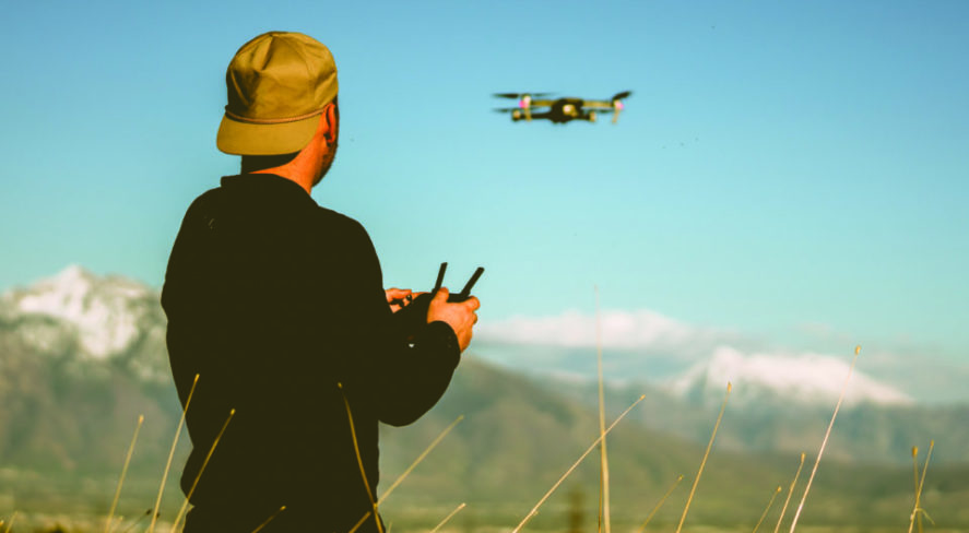
Consumer-grade unmanned aerial systems (UAS), also known as drones, promise to enhance lives and operations in significant ways. As with many new technologies, though, safety and privacy concerns abound.
Inexpensive and widely available, drones flown by clueless or careless pilots can create public safety hazards. Criminals or activists can spy on and record video of sensitive sites. They can even drop rogue access points on rooftops over corporate data centers or fly over corporate campuses to gather information from employees’ mobile devices.
And drone-borne terror attacks could threaten sites in the United States. This is not paranoia. Look at the short amount of time it took for airplanes to be weaponized. Less than 10 years after the Wright brothers’ first flight, a person flying a plane dropped a brick onto someone’s head.
It seems obvious that a person should have the right to defend against criminal or terroristic drone uses, but the reality is that very few legal remedies are available. In fact, because of the curious complexities of several laws, defenders against drones may find themselves in more legal trouble than the offending drone pilots.
Given that it is illegal for non-federal entities to use kinetic countermeasures against a drone, the next line of defense is detection. And, as with any security threat, the earlier the warning, the better. Early detection of drone threats in the airspace provides more time to respond effectively. Luckily, there are many drone detection systems on the market today, but they all work differently, and each has its strengths. The following 10 questions should be considered when evaluating drone detection systems.
1. What Is a Drone Detection System?
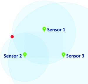
A drone detection system typically consists of two key components:
- Sensors that detect drones in the airspace, which may include both physical sensors and the computers required to process the data that is collected
- A user interface that displays drone detection data hosted on a local server or in the cloud
2. What Are the Different Types of Drone Detection Sensors?
The Federal Aviation Administration (FAA) divides four commonly used sensor types into primary and secondary categories.
Primary Sensors
Primary sensors are able to detect drones with high enough accuracy and low enough false alarm rates to operate as standalone solutions. That is, they do not require data from other sensor types in order to validate their detections. The two types of primary sensors are:
- Radar
- Radio frequency
Secondary Sensors
Secondary sensors need additional data from other sensor types in order to accurately detect drone threats with a low false alarm rate. These additional sensor types can be used to enhance the accuracy of – or provide more detail about – drone threats, but they cannot be used as a standalone system. Examples of secondary sensors include:
- Acoustic
- Camera/infrared
3. How Do Drone Detection Sensors Work?
Radar
A radar system consists of two components, a transmitter and a receiver. The transmitter sends a radio signal in a particular direction, and the receiver detects the echoes off any objects in the path of the signal.
Radio Frequency (RF)
An RF system detects the signals transmitted between the drone and the controller. As a result, if a drone and controller are within range of the sensors, it can detect them even before a drone takes flight – which provides very early warning. This also makes RF detection unique because, unlike other systems, it can detect the controller, which means it can identify the location of the pilot.
Acoustic
Acoustic sensors listen for noises in the environment, and the data provided by the sensor helps confirm whether or not a drone is in the area.
Camera/Infrared
Some camera systems can detect movement but require a complementary system to confirm that the movement is a drone and not, say, a bird or a piece of trash blowing in the wind. Other camera systems are used to gather visual evidence, but data from another sensor is needed to tell the camera which way to point.
People often ask if an RF system can detect a drone that is flying autonomously on a pre-programmed path. Typically, the answer is yes, because even in this situation, the drone sends a periodic signal to “check in” with its controller to make sure there are no updated instructions.
4. What Are the Pros and Cons of the Different Sensors?
Each type of sensor has its own advantages and disadvantages. See this chart for details.
| SENSOR TYPE | Pros | Cons |
|---|---|---|
| Primary Sensors | ||
| Radar | Very long range Provides altitude | Detects anything that moves, therefore has a high false positive rate in a busy urban environment Cannot detect until a drone is in flight Cannot detect a controller Actively transmits a signal, which may not be appropriate for all environments |
| Radio Frequency | Only solution that can detect both drone and controller Does not require line of sight Can detect a drone and controller as soon as they are turned on and connected (before flight) | System must be configured to filter out ambient RF signals Location accuracy may vary depending on the environment Performance degrades in heavy RF environments |
| Secondary Sensors | ||
| Acoustic | Does not require line of sight | Must be combined with another detection method High false positive rate in noisy urban environments Very short range Cannot detect a controller |
| Camera/Infrared | Easily captures visual evidence | Requires line of sight Must be combined with another detection method to guide camera angle |
5. Should Redundancy Be a Concern?
It is important to consider the impact on a drone detection system if a sensor fails, whether by sabotage or component failure.
A camera-based or acoustic system would simply be “blind” or “deaf” in the failed sensor area.
Depending on the configuration of a radar-based system, the system would be either somewhat degraded in a distributed model or totally down in a centralized model.
Some RF systems require multiple sensors: one to detect and three to locate. If the “detector” goes down, the system may still operate for some drones, but much more slowly. If a “locater” sensor goes down, the location accuracy degrades.
For RF systems that use a single detector/locator sensor type, consider a minimum of four sensors to provide for redundancy in system deployment. Three sensors provide the most accurate location information so, if one is down in a four-sensor deployment, location information can still be provided.
6. How Many Sensors Are Needed to Protect a Facility?
It varies a lot. And there are many considerations, including:
- Facility size: How large is the site? Larger sites require more sensors, not just on the perimeter, but potentially in other areas, too.
- RF environment: Some sensors simply do not work in extremely busy RF environments. For sensors that do work in such areas, detection range is reduced, along with drone flight range, so more sensors will be required.
- Topography: Are there any hills, cliffs or large buildings in the area? Do the structures or traffic change regularly? Buildings, metal structures and hills all affect drone and controller detection and location accuracy. Sensors that require line-of-sight will be defeated. Drone signal distortions caused by environmental elements render some RF-based systems inoperable. Other RF systems continue to function with somewhat degraded location accuracy.
7. What Is the Range of a Drone Detection System?
This is one of the most misunderstood questions. The reason is, most detection range statistics are based on ideal conditions: a clear, sunny day in a flat, open area with no major obstacles, like buildings, hills or other moving objects, or signal transmissions, like Wi-Fi networks, cell phones, metal detectors or dashcams.
So if a facility is located in the desert, a vendor’s statistics can probably be taken at face value. But if not, the vendor should be asked whether they have deployed in an area similar to where the facility is located. Ask them about the detection range in those specific areas. And even then, understand that every environment is unique, so range estimates will be a guide, not a definitive answer.
8. How Do RF Drone Detection Systems Locate a Drone or Controller?
First, it is important to establish that there are RF-based drone detection systems on the market that extract the GPS coordinates of a drone and controller from the signals they send. There is just one problem with this: it is illegal. It requires the system to demodulate and decode the signal, which violates federal wiretapping laws.
With legal systems that use the physical characteristics of a signal to identify location, there are two key methods: triangulation and trilateration.
Triangulation
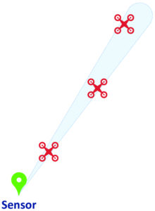
In triangulation, the sensor uses the angle of the signal to determine the approximate line of approach. Typically, it is accurate to within +/- 5 degrees, so it is best represented by a cone.
The triangulation method, however, cannot tell how far away a drone or controller is from the sensor. The drone could be anywhere along the angle of approach.
The intersection of three cones is required to locate a drone or controller.
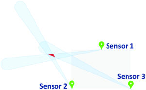
Trilateration
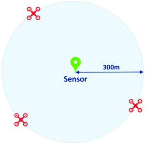
In trilateration, the sensor uses the power level of the signal to calculate the distance of the signal from the sensor. A drone or controller could be anywhere at that distance, so this is best represented by a circle.
The intersection of three circles is required to locate a drone or controller.
Pros and Cons of Triangulation
Triangulation provides early warning of the approach path, even if only one sensor is initially detecting, so security personnel immediately know in which direction they need to go. However, because one sensor cannot provide distance information, this can result in a high false positive rate, as a drone may be too far away to be a threat.
RF signals can reflect off of many surfaces, including buildings and vehicles, and this can diminish location accuracy. In the case of a reflection that results in no overlapping cones, it can prevent the system from locating at all. While this may affect drone location accuracy, the greatest impact is to controller location accuracy.
Pros and Cons of Trilateration
Trilateration allows for the setting of a distance threshold for alerts, which can reduce the false alarm rate. However, the system will require data from more than one sensor before security personnel can know where to respond.
| RF Location Method | Pros | Cons |
|---|---|---|
| Triangulation | Provides early warning of the approach path | When only one sensor is used, may result in a high false positive rate if drones detected are too far away to be a threat Signal reflections off objects like buildings or vehicles degrade location accuracy (and sometimes the ability to locate at all) |
| Trilateration | Can be configured to only alert to drones within a certain distance of a facility to reduce false alarms Able to locate even if signals are reflected off buildings or vehicles | Does not provide early warning of the approach path |
Because signal reflections have very little impact on signal power levels, a system that uses trilateration will be able to detect drones and controllers even in busy urban environments.
9. How Should Desired Outcomes Be Defined?
Goals and response tactics drive the type of drone detection system that is right for a given organization and situation.
Drone vs. Pilot
The system may be called drone detection, but the reality is, not much can be done about the drone. Outside of the military and federal government, mitigation is illegal. And even if mitigation were lawful, would an insurance company provide liability coverage if an organization’s security personnel caused a drone to fall from the sky and injure a person or damage property? Maybe not. So the best option to stop a drone from flying is to find the controller.
If the controller can be found, so can the pilot. If the pilot is just a careless or clueless operator, security personnel can ask him or her to land the drone. In the case of a bad actor, local law enforcement can make an arrest.
Accuracy vs. Reliability
Drone detection requests for proposal (RFPs) often contain a lot of technical questions. They ask for details on range, location accuracy, and time to detect, which is not surprising. Organizations are under pressure to use more data to justify decisions. What’s more, hard data feels much easier to compare than lists of features and capabilities.
But what will provide the best outcome? A system that has a long range and provides high location accuracy, but has a high false positive rate, so security tends to ignore the alerts? Or one that provides a good approximate location with a low false alarm rate, so security personnel take detection notifications seriously? It is something to think about.
Lots of Arrests vs. No Drones in the Airspace
How will the success of the drone detection program be measured? What is the goal? Often, when organizations start to plan, their goal is to get the bad guys. Lots of warnings or arrests equal success. But when a drone detection system is deployed, and security staff is empowered to respond quickly and effectively, something else often happens.
The drone threat is reduced as drone operators learn to stay away from facilities where security comes after them. At the end of the day, the best outcome is to eliminate the drone threat altogether.
10. Will Regulations Change to Allow More Active Countermeasures?
Drone technology moves quickly. Regulatory changes do not. Most security personnel regard taking a “wait-and-see” approach as not being a responsible option. Situational awareness of drones in the airspace provides actionable knowledge of a security risk. Pilot detection and location information give a security team a chance to prevent an incident from occurring, and that is an effective form of mitigation.
 Back to Top